Which trails are close to me and where are the best ones? Choose your destination below to see full size trail maps and detailed descriptions of the area
The Snapshot View below categorizes parks and trails by geographic region within Kitsap county
Take a peek into each park before making a choice. Click any trail map image to open detailed trail maps and display practical information for your destination
Snapshot view
North Kitsap County Trails
Including parks near Hansville and Kingston
Hansville Greenway Trails
An extensive trail system in north Kitsap County crossing mature forest and recently cut areas from Hood Canal to Puget Sound.
Also known as the Sid Knutson Puget Sound to Hood Canal Trail, enter at one of many trail access points and walk or bike all or just one section.
Point No Point County Park Trails
A scenic Kitsap County park featuring a historic lighthouse, a wide beach, and a short, but stimulating trail from the beach to the top of a forest-capped bluff
Foulweather Bluff Trails
Owned and managed by the The Nature Conservancy, this relatively short trail escorts you through coastal forest and around a large marsh, a haven for water birds and other wildlife.
Nearly 3/4 miles of undeveloped beach on Hood Canal allows you to see this scenic and significant preserve first hand.
Port Gamble Reservation S'Klallam Tribe Trails
A North Kitsap reservation with large forested tracts of land adjacent to the tribal administrative buildings.
Unpaved forest roads open to everyone meander through the woods, an excellent resource for mountain bikers, walkers, and runners.
Kingston-eglon Trail
A little-known spot north of Kingston with trails for mountain biking, horseback riding, and walking.
Trails primarily follow unpaved road beds and are kept clear by a local resident
Central Kitsap County Trails
Including parks in Bremerton and Silverdale
Ueland Tree Farm Trails
A huge privately owned tract of forest with miles of great mountain bike trails and a popular waterfall hike.
Open to the public for decades, this park just outside of west Bremerton is a great resource for walkers and mountain bikers
Green Mountain State Forest Trails
A working multi-use Washington State Forest with a network of trails traversing the ‘mountains’ of Kitsap County.
A Variety of hiking and biking trails provide multiple routes to scenic views of the Olympics and Seattle.
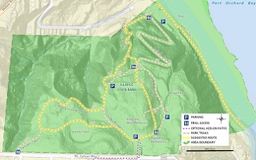
Illahee State Park Trails
A great and easily accessible state park close to town and featuring a short, but stimulating trail with beach access. A long pier offers a vantage point for amazing water views
Illahee Preserve Heritage Park Trails
A well-preserved forest park with several miles of quiet trails at the edge of Bremerton’s retail corridor
Newberry Hill Heritage Park Trails
A large county park with 10+ miles of trails suitable for walking or mountain biking. Single-track and wide paths provide multiple loop routes
Anderson Landing Preserve Trails
A county park west of Silverdale offering a good loop trail and access to a picturesque and marshy beach
Scenic Beach State Park Trails
A state park west of Silverdale and Bremerton offering a up to 3 miles of walking opportunities and access to a beautiful beach
Guillemot Cove Nature Reserve Trails
A county park west of Silverdale and Bremerton offering 3 miles of trails leading to a wetland, an unspoiled beach and several interesting points of interest
Clear Creek Trail
A well-maintained trail system through greenways in the urban retail core of Silverdale.
The trail is actually a series of connected and disconnected paths covering around 8 miles of trails with paved walking and biking trails to boardwalks over wetland areas, and gravel or natural surfaces through forest
Forest Ridge Park Trails
A City of Bremerton neighborhood park near the Callow/Burwell intersection with short forested trails and an optional neighborhood walk with city views
Stephenson Canyon Park Trails
A City of Bremerton neighborhood park with wooded trails through a pleasant creek canyon near Lebo Blvd and Lions Park
Madrona Trails
A City of Bremerton neighborhood park with trails through forest with large patches of red-tinted Pacific Madrone trees next to Harrison Hospital
Kitsap County Fairgrounds Trails
Expansive fairgrounds property with trails through forested disc golf courses and additional walking opportunities throughout the grounds
N.A.D & N.A.D Marine Park Trails
A City of Bremerton park with a military history. Split in two by HWY 3, these are two distinct parks. The N.A.D Marine Park has connects to Jackson Park waterfront trails and is well worth the trip.
South Kitsap County Trails
Including Parks in Port Orchard, Manchester, and Olalla
Manchester State Park Trails
A scenic State Park on the water east of Port Orchard.
Trails through forest, along the coast, and around campground loops combined with some military history make this out of the way destination one to look forward to
Wynn-Jones Preserve Trails
A 55 acre well-preserved tract of prime forest land donated to the county featuring just a mile of trails.
Small and off the beaten path, you most-likely won’t encounter anyone else here
Anderson Point County Park Trails
A 66 acre county park featuring a trail leading downhill to a wonderful beach.
The trail is an unpaved road bed, but the highlight is the very walkable beach with views of Vashon Island.
Square Lake State Park Trails
A 231 acre state park with a marshy lake as its centerpiece and surrounded by forest.
Square Lake receives few visitors and may soon transition to a a county park.
McCormick Woods & coulter Cr. Trails
Owned and managed by the private golf neighborhood Association, this extensive trail network is well-maintained and open to everyone.
Over mostly level ground and featuring an abundance of entry points and walking options, anyone can enjoy waking around the wetlands and forest that dominate this area.
Still not sure which hike, walk, or ride is best for you? Check out the interactive trail map to browse parks and recreation areas throughout Kitsap county and see which hiking trails are close to Bremerton, Poulsbo, Silverdale, Port Orchard or wherever you live in Kitsap County.